Day 1.
The team will meet at the airport in Santa Marta (Time not specified).
From there We will move towards Palmor on around 3 hrs ride.
Will spend the night at some farm of the area.
Day 2.
Start of the treking (Around 2hrs on a 4×4 ride)
Treking to Mamarongo (1602m)
5 – 6 hrs walk
15,6km
Ascent 256m
Descent to the Setay river 363m
Ascent to Mamarongo 256m
Early morning The team starts from Palmor towards the end of the road ( a very bad road). We will try to start walking in the fresh hours of the morning.
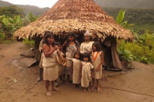
Lunch at the Setay river and later upon the arrival at Mamarongo a formalization of the permits will be done with the local authorities (Mamos etc.)
Day 3.
There is high possibility that the local authorities will tell us that we must remain a day in Mamarongo for the authorization; If not, We will keep towards with the program (day4), if we have to stay we have the chance to know more about the Kogui culture and eventually walk to a waterfall, located 45min from town.
Day 4.
Mamarongo – Urameke 2310m
5hrs Hike
9,7kms
710mts ascent
Ascent through the Tukurinka river.
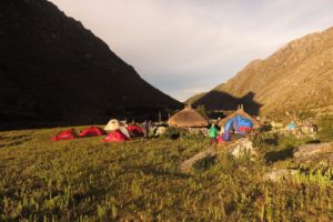
Camping in a small indigenous village.
Day 5.
Urameke – Dibungi 3604m
5hrs Hike
8,2kms
1292m ascent
From high Andean jungle to Sub-Paramo.
Day 6.
Dibungi – Nautaneda 4,433m
5hrs Hike
5,8kms
829m ascent
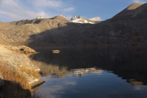
Ascent through the Viscungue river to the Arucuma lagoon.
From there to the Nautaneda lagoon, where we spend the night at tents with nice views to the Sierra Nevada peaks.
Day 7.
Nautaneda.
Acclimatisation day.
Free day with possibilities on small hikes to the Lagoons or small peaks.
Day 8.
Nautaneda – Ruiz Wilches peak 5,290m – Nautaneda
10hrs hike
12km
857m ascent
Early morning 3am aprox The team will be lead towards the high camp 4889m of Simmonds peak, and from there We will ascent to Ruiz Wilches peak (5290m).
Views: Simmonds peak, Colon and Bolivar peaks among others – If the weather is stable we can have the chance to see the Caribbean Sea.
Day 9.
Nautaneda – Dibungi
4hrs Hike
6km
Descent 829m
Early morning the tents will be packed up and we will start the descent.
Day 10.
Dibungi – Mamarongo
7hrs hike
Descent 2002m
Day 11.
Mamarongo – Uranio – Palmor – Santa Marta
6hrs hike
15,6km
256m descent
363m Ascent
2-3hrs Jeep ride (Uranio – Palmor)
3hrs 4×4 ride (Palmor – Santa Marta)
We will leave Mamarongo as early as possible in order to avoid the noon heat.
At Uranio, Jeeps are waiting to descent to Palmor. From there we will be lead directly back to Santa Marta End of the trip.
Includes:
• Food and gear on the expedition (Tents, sleeping bags, mattress, stoves)
• 2 Mountain guides
• Mules
• Porters/Chef/Local guides
• Indigenous that “links” the expedition with the local authorities.
• Transfer from Santa Marta and back to Santa Marta.
• Fees that the Kogui culture charge to enter to their territory.
No includes:
• Airplane tickets
The realization of this itinerary depends on the will of the local authorities (Koguis).
If something is cancelled we will return money as far as possible, minus bank transfer fees.
Local guides will ascent to the communities ten days before the start of the expedition to check that everything is smooth and ready for the trip.